Tag Archives: kayaking

How Canada Ranks In World For Thrill Seekers

With over 40% of travellers looking for heart-pounding thrills in 2024, the global adventure tourism market is predicted to grow to a staggering 2,824 billion usd dollars/ 3,840 billion cad dollars at time of publishing by 2030, as more seek adrenaline-fuelled experiences.

So if you are a relentless adventure junkie, which countries should be on your radar this year?

Our friends at BestCasinoSites.net evaluated factors including the number of roller coasters, casinos, rock climbing opportunities, mountain bike routes, hiking trails, and off-road trails in 61 countries, to compile a global index ranking the best countries to visit for thrill-seekers.
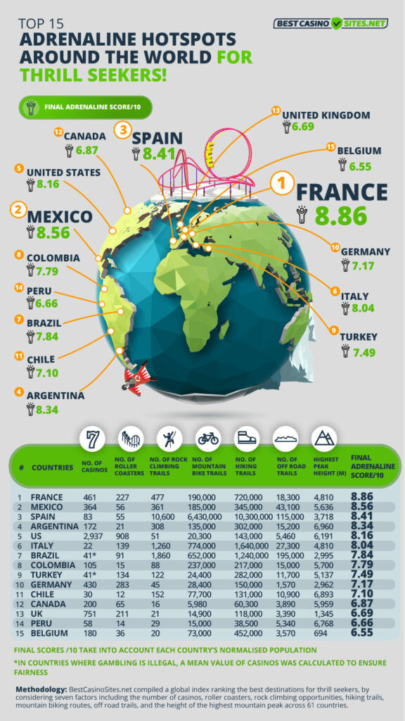
Canada among top 15 countries for adventure lovers

From biking the Gulf Islands to ziplining over Niagara Falls, Canada ranks 12th best country to get that adrenaline fix, earning a notable final score of 6.87/10. With 60,300 hiking trails and 5,980 mountain biking routes, Canada boasts a geographically diverse landscape and is home to North America’s second-highest peak, Mount Logan, topping out at 5,959 meters.
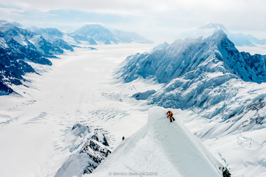
Mount Logan is a whopping 6KM in elevation and ranks sixth in the world for most prominent peak.

Adrenaline checklist in Canada: Experience Niagara Falls on a zipline, Rock or ice climb in the Rocky Mountains, Jump over the Cheakamus River with Whistler Bungee.
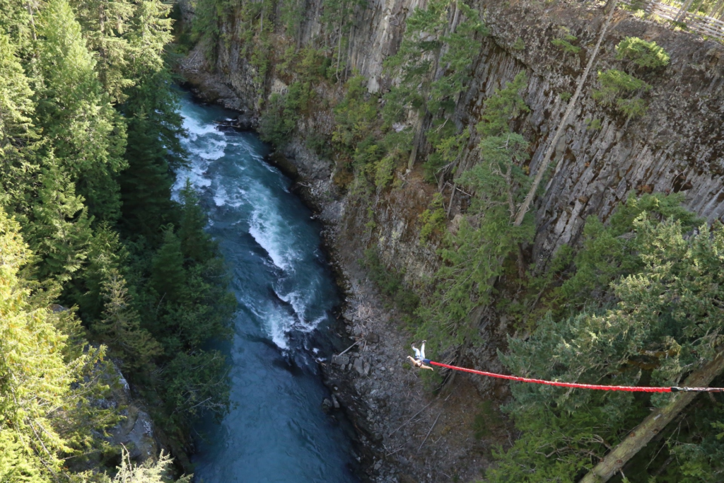
Whistler Bungee: offering a 160 foot jump over the glacially fed River below.

France reigns as the adventure capital of the world

According to the study, France is the world’s adventure capital, boasting an overall adrenaline score of 8.86/10. Prized for its stunning mountain ranges from the Pyrenees, Alps to Chamonix, the country offers over 720,000 hiking trails. Test your limits by conquering Europe’s highest peak, the Mont Blanc ranges, towering at 4,810 metres, or by jumping on one of France’s 227 thrilling roller coaster rides!

Adrenaline checklist in France: Cliff Jumping from the Calanques, Rock climbing overhanging limestone in Provence, Cycling on a glacier.

Trailing behind in second is Mexico, achieving a final score of 8.56/10. Your journey to this Latin American gem can be incredibly action-packed as you scale Mexico’s iconic snow-capped cone, Pico de Orizaba, with a peak of 5,636 metres above sea level; tackle one of the world’s biggest sport climbing areas at El Potrero Chico; or indulge in the thrill of games at any of the 364 casinos* Mexico boasts.

Adrenaline checklist in Mexico: Extreme urban downhill biking in Taxco; Bungee jumping at Los Cabos, Zip-lining in the Jungles of Yucatan.

The land of paella and sangria ranks as the third must-visit destination for adventurous souls, scoring 8.41/10Spain offers an enticing array of outdoorsy pursuits, boasting the highest number of thrill-seeking trails – from rock climbing (10,600)mountain biking (6,430,000), to hiking (10,300,000) – among all cities studied. Spain’s pristine landscape appears tailor-made for adventure enthusiasts.

Adrenaline checklist in Spain: Rock climbing In Picos De Europa; Canyoning at Junta de los Rios; Andalucía, Walking the El Caminito del Rey.

Argentina takes fourth place, earning an impressive final score of 8.34/10. Home to the third highest peak (6,960 metres) in the study, The Aconcagua attracts over 3,000 mountaineers annually, despite being nicknamed the ‘Mountain of Death’. With a whopping 172 casinos*, including South America’s largest casino complex, the Trilenium, Argentina offers ample opportunities for both seasoned risk-takers and casual players alike.

Adrenaline checklist in Argentina: Mountain biking in Bariloche; Ice trek on top of Perito Moreno Glacier, Paragliding with Condors in Córdoba.

From kayaking down the Grand Canyon to cliff camping in Colorado, the United States rounds off the top five adrenaline hotspots, earning an impressive final score of 8.16/10. With the highest density of casinos in the study totalling 2,937 across the country, and over 900 roller coasters – including the world’s second-fastest roller coaster, Kingda Ka – America is a must-visit if you crave the rush of adrenaline.
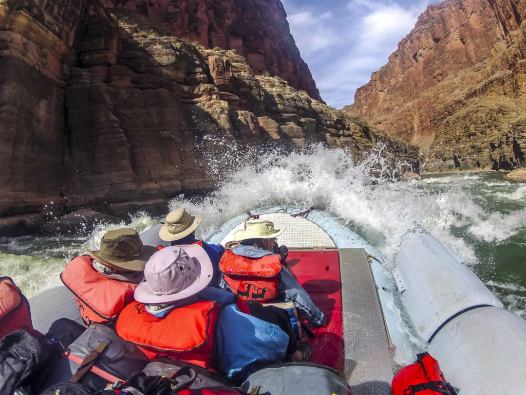
Adrenaline checklist in the US: Rafting in the Grand Canyon, Mountain biking the Grand Staircase in Utah, Rock Climbing in Yosemite National Park.

For the Silo, Alasdair Lindsay.

Methodology

  1. The experts at BestCasinoSites.net compiled a global index ranking the best countries for thrill-seekers by considering seven factors, including: (i) Number of casinos (ii) Number of roller coasters (iii) Number of rock climbing trails (iv) Number of mountain bike trails (v) Number of hiking trails (vi) Number of off road trails and (vii) Highest peak height in each country.

Note: Countries with more than two missing values were omitted, resulting in 61 countries in the final dataset.

  1. The experts collected the data from the below sources:

(i) Number of casinos: https://www.casinocity.com/casinos/ 

Note: In countries where gambling is illegal, the average number of casinos of all countries was taken (excluding US because of being a huge outlier) to ensure fairness and avoid penalising any specific country.

(ii) Number of roller coasters: https://rcdb.com/location.htm

(iii) Number of rock climbing trails: https://www.wikiloc.com/trails

(iv) Number of mountain bike trails: https://www.wikiloc.com/trails

(v) Number of hiking trails: https://www.wikiloc.com/trails

(vi) Number of off road trails: https://www.wikiloc.com/trails

(vii) Highest peak height in each country: https://flagpedia.net/lists/highest-point 

Note: The number of rock climbing, mountain bike, hiking and off road trails were sourced from user-posted data

  1. After collecting the numbers, the experts logarithmically normalised the figures in order to reduce skewness between countries with different sizes.
  2. A final adrenaline score out of 10 was calculated for each country to reveal the top 15 adrenaline hotspots across the globe.
  3. All data was collected on 5th February 2024 and is correct as of then.

*It’s crucial to thoroughly review the rules and regulations governing gambling in various countries before engaging in any gambling activities.
River Water Levels Are Favorite Discussion Among Ontario Paddlers

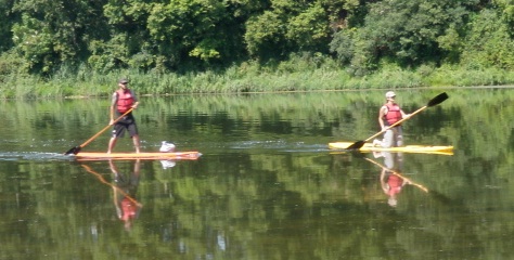
SUP- Stand up paddling is a popular sport along the Grand River system. image: grandriverrafting.ca

Is the water level in the river going to be okay for canoeing or kayaking on any given weekend?

This is a common question that people call the GRCA to ask. It is also an important question. Usually what  they mean is ” will there  be enough water?”, but occasionally, there is actually way too much water for most people to canoe or paddle safely.

Fly fishermen too need to check river levels so they are safe and don’t get swept off their feet by a strong current.

An angler will likely move to a different area rather than take a chance. As an organization, the GRCA does not make recommendations as to appropriate water flows for recreational activities along the Grand River and its tributaries because there are many variables to consider. Some people have the expertise and training to enjoy high flows that could be fatal to inexperienced and ill equipped paddlers.

Very low flows make for slow going as there may not be enough water for the canoe to float and it may need to be pulled to deeper water at certain times. A skilled paddler will be able to read the water to find the deepest water and will have fewer problems. Some people have a bad day if they have to step out of their boat even once, while others are more tolerant of low flows. That is why there is no definitive answer to this question.

Appropriate water levels are a favorite discussion among paddlers. Those who paddle regularly have their own personal chart, whether it is in their head or on a spreadsheet.

Checking flow information

Many avid river recreation enthusiasts in Southern Ontario bookmark the River Data section of the GRCA’s website and check it when trip planning. This is one of the most visited sections on the GRCA’s website and provides hourly updates on river flows from 39 gauges on the Grand and eight tributaries. Some gauge information is also posted on an Environment Canada website that includes rivers in other parts of Canada, but the GRCA site has data for more gauges from this
watershed.

The main chart here is called the Flow Summary.

Recreational users should pay attention to the column headed “flow.” This one is measured in cubic metres per second or cms. If the rate is 10 cms, that means that 10,000 litres of water is moving past the flow gauge each second at this part of the river. The cms gets bigger as the river moves towards Lake Erie. There are huge changes in river flow due to seasons, weather, ice jams and dam operation.

Compare this to the “summer lowflow” which is the average flow during the dry summer months and you will see in relative terms how much water is flowing down the river. Following this Flow Summary is a list of sections of the rivers and tributaries with graphs. For example, one of the most popular sections of the river for a day trip, Cambridge to Paris, a paddler would check the Galt gauge on the “Middle Grand River“section. The graph will tell you if the level is going up, down, or holding steady. Occasionally a flow gauge does not operate and the information can be inaccurate, so the information is provisional. There is also a River Flow Information line that is updated regularly and can be reached at 519-621-2763, ext. 2511.

Photo by Judi Thompson

Outfitter information

There are several local outfitters in the area and they have cut off levels, when they stop canoe rentals. Canoeing the Grand in Kitchener has a safety section on their website with a five step rating chart for paddling. This scale  goes from “Excellent” to “No Go” with five levels, depending on the paddler’s age, skill, expertise and river conditions.

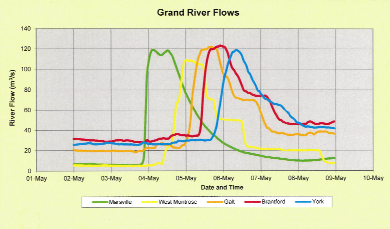
Grand River flow rates chart

When river flows skyrocket

As the graph above shows, the Grand River may not give much warning of a sudden increase in river flows, which is why the GRCA must sometimes issue high water safety warnings to the public. This is the flow information from the week of May 2 to 9 from a few years ago. Note that it shows heavy rain on Thursday night May 3 in the northern part of the watershed meant flows ballooned from 8 cms to 120 cms within a couple of hours, as the data from Marsville shows. The GRCA issued a warning after the storm. The rainwater gushed down the river and by the afternoon of Friday May 4, flows were dropping at Marsville but skyrocketing at West Montrose. By Saturday May 5, the river flows in Brantford were extreme and then they peaked at York on the southern Grand on Sunday.
A final important note, Dams can make the impact of a rainstorm less severe but they don’t eliminate flooding or high flows.

For the Silo ,Janet Baine, GRCA Communications Specialist

New Way Of Experiencing New York Adirondack Mountains

Wild Walk, or the “High Line of the Forest” is changing the way people experience and interact with nature, and is just another reason to travel to the revered Adirondack Mountains this summer.

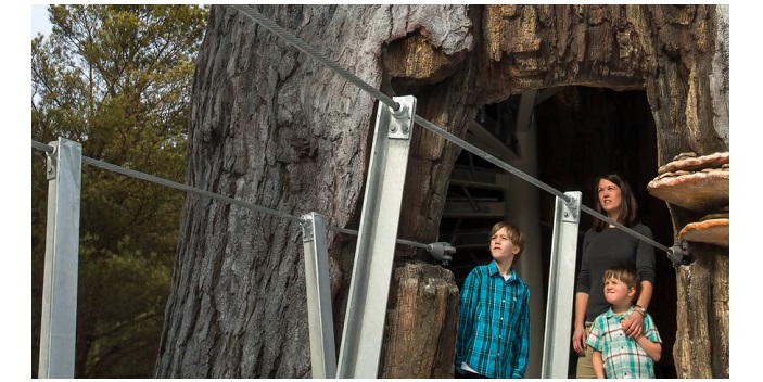
Adirondack Mountains Hollow Tree Platform

An elevated path that takes visitors up a winding trail of bridges and platforms from ground level to breathtaking treetops, Wild Walk gives visitors a novel and one-of-a-kind perspective on nature from groundbreaking angles such as a four-story twig tree house, swinging bridges, a human-sized spider’s web hovering 24-feet off the ground and a walk through a giant dead tree to see the amazing life thriving within.

Wild Walk Preview Video from The Wild Center on Vimeo.

Demonstrations at vantage points throughout the walk bring everything to life, such as how spiders can 3D print different threads for different uses, that within a dead tree is actually something more like a high rise building filled with life, and more.

Quick Facts:

  • This summer marks the 11th anniversary of The Wild Center, a pioneering “un-museum” that helps people not only explore the Adirondacks but their relationship with nature.  
  • Gas Prices: If gas prices decrease as predicted and with travelers heightened interest in exploring the US – this is the summer for road trips
  • The Power of Awe: Studies show that a sense of awe (often caused by majestic, natural landscapes) can make you happier, less-stressed, and more creative – one more reason to make nature a focus for summer travels this year
  • Adirondacks: The untouched and authentic Upstate New York experience for all ages with additional attractions including camping, glamping, kayaking, local breweries, wineries, farmer’s markets, Lake Placid and more
  • Family Travel: Educational and entertaining trips where kids are safe to run free and explore; the boardwalk is also wheelchair and stroller accessible
  • Accessibility: Wild Walk is accessible to people of all generations and abilities. There will be side paths and options to take, suspension bridges, and stairs down, but the entire main structure, from the trail leading to Feeder Alley all the way to the viewing pod on the final tower platform was built specifically so that it would afford everyone the chance to experience the Walk.

For the Silo, Alexis Chernoff