Silo/HNARP- Can you tell our readers a bit about the history of the bridge, for example the year in which it was first built and its age?
The Grand River Cayuga Bridge is a 5-span through-truss bridge. Construction began in 1923 and was completed in 1924.
Silo/HNARP- So why is the bridge being redesigned and rebuilt?
To ensure our provincial bridges remain safe, Ontario is the only province in Canada to legislate that owners must inspect their bridges every two years by, or under the direction of a professional engineer. Taking it one-step further, MTO also conducts routine maintenance inspections of all 2,720 of our provincially owned bridges every year.
As part of our assessment, the Grand River Bridge, while currently still in safe condition, was identified as requiring future replacement, due to its age and declining condition. In 2005, the ministry initiated a Preliminary Design and Class Environmental Assessment (EA) Study to determine the long-term strategy for the bridge. Completed in 2008, the Study recommended the bridge be replaced with a 5-span, steel girder bridge. The Study received Environmental Clearance in November 2008.
Silo/HNARP- Can you explain to us the importance of archaeology to the MTO in Ontario and its support of the Heritage Act?
It is a requirement of the Ontario Heritage Act to address the impacts of any project on both archaeological resources and the built heritage environment, MTO achieves this as part of the Environmental Assessment we conduct for every MTO undertaking.
Silo/HNARP- Is the archaeology holding back the bridge’s development or is the project on schedule?
The ministry’s preliminary design and Class EA identified prehistoric and historic archaeological sites along the west side of the existing bridge, so it was acknowledged that some special measures and precautions would be necessary. The archaeological salvage work has been scheduled into the timeline of the project, and is on track.
Silo/HNARP- Did the MTO know in advance that extensive archaeological work was necessary?
The archeological assessment completed during the EA Study identified that prehistoric and historic archaeological sites are located along the west side of the existing bridge. Based on the results of a Stage 3 archaeological assessment (test trenches) completed during Preliminary Design, it was determined that a Stage 4 Archaeological Salvage had to occur to ensure existing artifacts are recovered before any areas are disturbed as a result of construction. In 2009, the ministry started the detail design study and retained a consultant (McCormick Rankin Corporation) and their sub-consultant, New Directions Archaeology Ltd., who are responsible for completing Stage 4 Salvage under an archaeological license issued by the Ministry of Tourism and Culture (MTC).
Silo/HNARP- The general public has noticed the excavation taking place one layer at a time. Why has this been important?
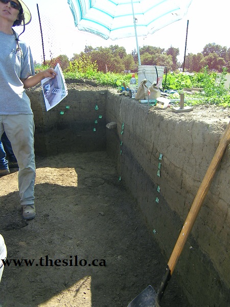
This is a very significant archaeological site made up of a series of cultural layers representing different historic and pre-contact occupations at this location. Based on previous studies, the artifacts range in age from the Archaic period, circa 8000 – 1000 B.C. through to the historic period circa 1700+ A.D. The west bank of the Grand River around Cayuga is a flood plain. Because the periodic flooding of the Grand River deposited silt over this flood plain, this site is made up of numerous levels of cultural material, each dating to a specific time frame, sandwiched between sterile layers of flood deposits. The goal of the excavation is to map and record these cultural layers before they are impacted by construction. To do this, the excavation is being completed in one metre by one metre squares, recording the original location of each artifact within the one metre square, including the depth at which it was recovered. The artifacts from each one metre square will be kept together, with individual levels kept separate in clearly identified bags. This will ensure that each artefact will be related to a specific cultural level and time period, to interpret the history of the site.
The excavation of each one metre square will continue downward until no further artifacts are recovered. Based on previous test excavation on the site, this will be at a depth of about 160 cm. The excavation will continue below this depth to ensure that all artifacts have been recovered, generally to a depth of approximately 180 cm (1.8 m).
Silo/HNARP- What unique discoveries have resulted at the site such as historic, pre-contact, archaic items?
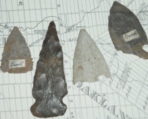
The site is yielding an array of artifacts, including ceramics (pottery), tools (scrapers, spear points, arrow heads), stone flakes from tool making and even a shell bead, thought to be an early trading item.
Silo/HNARP- Why has the Six Nations been involved with this project?
First Nation involvement is an important aspect of this project because of the significant archaeological resources at this site. MTO and our consultants have regular and ongoing consultation with interested First Nations regarding this project. People from Six Nations have been hired for the archaeological field investigations and monitoring of the salvage operations, as well as the follow-up lab work.
Silo/HNARP- What will the MTO do with the artifacts once the project is finished. Will there be any public education about what was found?
Once the excavation of each one metre square is complete, the artifacts will be removed from the site and taken to a lab where they will be washed and organized. The artifacts will be analyzed and discussed in a final report including conclusions about the prehistoric activities at this site. Given the scope of this excavation, the analysis and reporting of this site will take years to complete. Once the report is finished, the artifacts will be kept for posterity, available for other archaeologists who are interested in the site and the time periods represented. Discussions are currently underway with a few Ontario university repositories to house the artifacts.
Silo/HNARP- How and where can the community learn more about what was recovered and learned from the excavation when the project is finished? Is there for example, an online PDF document, field report or analysis report of artifacts?
A report will be prepared after the artifacts are analyzed. The report may take a few years to complete, due to the size of the excavation. It will be filed with MTC and also provided to the First Nations having an interest in the site. Due to local interest, we also expect to provide copies to local repositories, such as the Haldimand Museum.
Silo/HNARP- Will this be the last season of field work before the bridge reconstruction gets started or is another field season anticipated in 2012.
It is anticipated that the salvage work at the current site will be completed in the fall of 2011. Additional areas of archaeological salvage may occur in 2012, if it is determined that construction activities will cause disturbance to additional areas on the west side of the river not yet salvaged.
Silo/HNARP- Who can be contacted to learn more about this archaeological site and its history?
The salvage work and report preparation are being conducted by New Directions Archaeology Ltd., under the direction of Mr. Phil Woodley. Questions about the site should be directed to the Communications Coordinator for MTO West Region (519-873-4186), who will consult with Mr. Woodley for detailed information as required.
Silo/HNARP- When is work expected to begin on the bridge replacement?
Construction is anticipated to begin in 2012 and is expected to take two construction seasons to complete.
