Tag Archives: hail

Ontario Storm Chasers Warn Public Through Photography

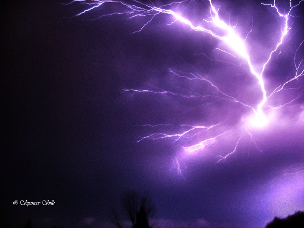
Photo shot in London, Ontario. Shot during a tornado warning for Middlesex county. photo: S. Sills

Did you know on average 12 tornadoes strike Ontario each year? That’s why David Chapman (@northof44pics) and I (@wxspencersills) commit our springs and summers to capturing severe thunderstorms on video and through photography.

My name is Spencer Sills and I am a chaser located in South Western Ontario. I have been chasing storms for about 20 years. I became obsessed with the weather and more specifically severe weather in 1996. On April 20, 1996 a tornado had hit Williamsford, Ontario. This was my first experience with a tornado and it has become a permanent fixture in my mind, partially due to the fact there was still snow on the ground the day it had hit.

Then in the summer of 2011, there were fourteen confirmed tornadoes including  the Goderich F3 tornado as well as three tornadoes during the August 24th severe weather outbreak during the late afternoon and evening. I was unable to be out during either of these days but what I was able to do was keep the public informed of the current severe weather as well as help give warning for the tornadoes.
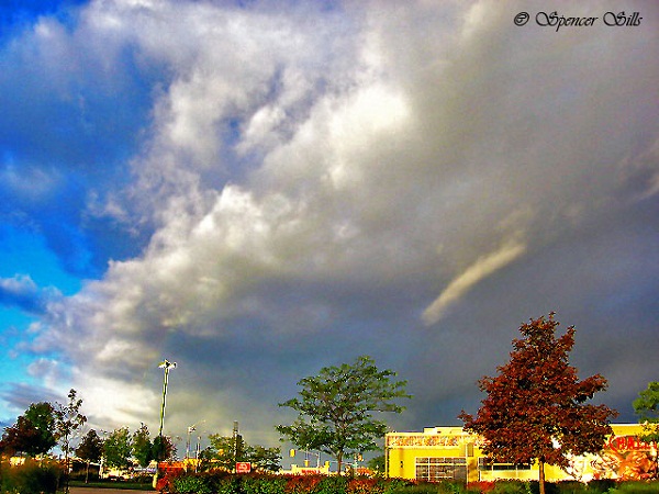
Photo shot in South West London, Ontario. A waterspout advisory was in effect for Lake Huron and Erie, while on the way to Lake Huron I came across this Cold Core Funnel off of a early morning thunder shower. image: S. Sills

A Summer from years ago was…interesting.  I witnessed more than  my fair share of active weather. I encountered five funnel clouds, several gust fronts or more commonly known as squall lines here in Ontario, and hail from pea size to golf ball sized  in Seaforth. I’ve also encountered strong wind storms which included a storm in Birr, Ontario which uprooted several large trees.

My personal worst storm occurred on June 7, 2011 in Elora, Ontario. A large and intense cell came through late at night bringing with it 80-90 km/h winds, heavy downpours, frequent lightning and quarter-coin size hail. I was fortunate to not be injured during this storm because I was in a tent at the time and had no warning beforehand other than a loud lightning strike before it hit. There was a severe thunder storm warning with the cell but our campground chose not to relay that information to campers and I only found out about the warning once I put on my portable radio after the storm came.  That same storm went on to produce a tornado warning over Hamilton but did not spawn a tornado that night. It did however cause extensive wind damage in the city.
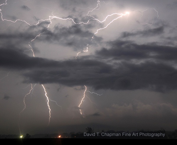
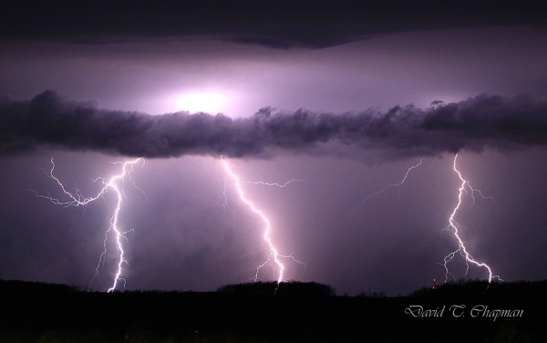
Cloud to Ground Lightning: photographed by D. Chapman

My chase partner is David Chapman.  David and I both grew up within minutes of each other but never met until recently due to the power of twitter.  From twitter I was able to glean that we both have similar interests and goals which will allow us to mesh well together. [ Check the hashtage #WX on twitter for tweets related to extreme weather CP ]

Hello Silo readers. My name is David T. Chapman and I am a professional photographer with a passion for storm photography. I developed an interest in weather when lightning hit my house in Guelph, Ontario, years ago. The thunder was terrifying and the rain was so heavy that even though I was only three years old at the time, I have clear, vivid memories of the storm. My interest in weather was rekindled in the late 1990’s when I spotted my first multi-vortex tornadoes with my dad and brother. Since then, I have followed the weather every day to determine the best time for photography in all kinds of conditions.

Waaaay back in 2011 , the Ontario storm season was an active one. It allowed me to get a personal record number of lightning photographs in one season with 105, not including sheet lightning shots. My first storm was in April, when a very weak storm pushed into the Niagara region. Something that you don’t see very often is a thunderstorm with snow on the ground, but that night I had both. But the storm chasing season  really didn’t start seriously until the end of May when an evening storm rolled through Southwestern Ontario right into my area. The squall line formed directly to our west and there was no way around it. We had to puncture the core of the storm to try to find a dry slot. We were hit hard with heavy rains, strong winds and continuous lightning.
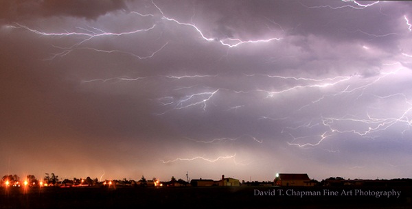
Anvil Crawler: photographed  Southeast of Hamilton, Ontario image: D. Chapman

One of the hardest things to get is a lightning photograph when there is a downpour because it blurs the image. The first line of storms went through when we crossed an open field area and then we were hit by a strong second line of storms. Extremely strong straight lines came at us with winds easily in excess of 90 km/hr. We got into position, but unfortunately, with the rain still pounding our photography team, it made it impossible to get crisp, clear lightning shots. It wasn’t until after the storm had passed that the back end of it lit up and we were able to capture some very beautiful lightning.

The summer carried on with sporadic thunderstorm activity consisting of small thunderstorm cells with intense lightning and hail. Generally, with smaller storms, you only get 4 to 5 lightning shots. I’ve come back after chasing a storm perfectly with only 1 or 2 lightning shots to show for it. It wasn’t until the outbreak of thunderstorms that our team had a very successful night of shooting. On that night, Faith Beni and I ended up in St. Mary’s, Ontario. There were tornado watches all across Ontario, the most I had ever seen. The thunderstorm cell that we were interested in was towards Nairn, Ontario. We left the Niagara region at 5:30 p.m. and got to St. Mary’s around 7:45 p.m.

Without daylight left, the thoughts of getting a tornado quickly changed to an opportunity for lightning photographs instead. One of the most dangerous things to do is to chase a tornadic thunderstorm in the dark, which is why our team has a policy to not chase these types of storms at night. We tend to focus on weaker storm cells that don’t have the tornadic potential but still have lots of lightning. The night of the 24th, though, was different. It seemed that any storm cell had the potential to drop a tornado. We pulled back to St. Mary’s and then we started getting reports of rotation heading to St. Mary’s.

In just under 2 minutes, I saw 4 reports of rotation for St. Mary’s. We started to get pounded with large hail and the the hydro went out. We left St. Mary’s and pushed north towards what looked to be some late evening twilight. We got to the back of the storm and were able to photograph the lightning that was in it. We got some of the best anvil-crawlers that I have ever seen. Anvil-crawlers are a particular type of lightning that can either go for short distances or for distances over 100 km.

This year for the first time, Spencer Sills and I will be working together to get some very powerful images. Our biggest goal is to get a photograph of a tornado. Last year, I was close 3 times. The first was in Grimsby, where an EF0 hit and damaged a small gazebo. Eric Chapman and I were right on the storm but unfortunately we could not see the tornado because of heavy precipitation. The second was the Nairn tornado and the third was a rotating wall-cloud that I photographed towards Bryson, Quebec.

Spencer and I often hear about how tornadoes don’t happen here. We want to let the public know that they can and do occur here, in South Western Ontario so that watches and warnings should always be taken seriously. The Goderich tornado in 2011, in which one person died, is a grim reminder of just how intense tornadoes can be and that they do, in fact, affect Ontario residents.
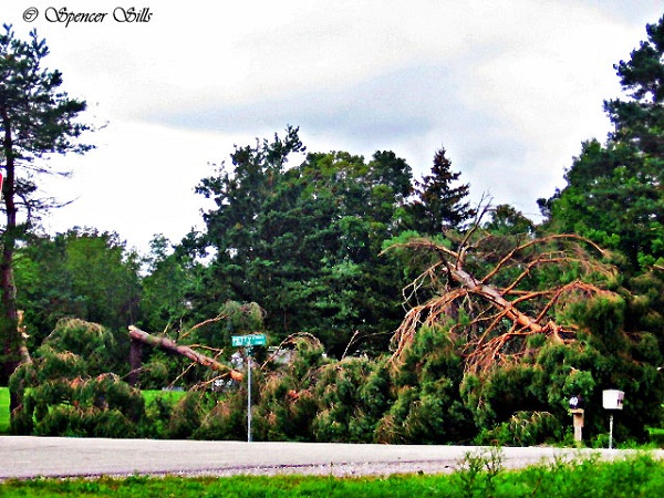
Photo shot in Nairn, Ontario. Tornado damage in Shady Pines Campground in Nairn. A tornado touched down the previous night and bent these pine trees in half, the tornado also caused extensive tree damage in the area as well as damaged a house and destroyed a metal silo. image: S. Sills

David and I both have experience in chasing storms, and take safety very seriously. We will be travelling with a First Aid kit just as well as weather alert radios and radar to help us along our way, we hope that we don’t ever need the kit but it’s always a great idea especially if others are in need of help, we could very well be the first people on the scene of a possible tragedy so we must be prepared. We will be posting pictures and videos throughout the season but do not recommend that anyone attempt to recreate either of them and place themselves in danger.

I will be working with David Chapman in hopes to help warn others as well as capture these storms through video and photography to share with others who may not get to experience them. We are ready to combine our passion for storms to get the best results possible and share those results with others.

Chasing Ontario’s Tornados

Part One

I have seen many storms in my life. Most storms have caught me by surprise, so I had to learn very quickly to look further and understand that I am not capable of controlling the weather, to exercise the art of patience and to respect the fury of nature”

My name is Spencer Sills, and I am a storm chaser, some of you may remember a few years back reading about my good friend David Chapman and myself in this very newspaper and our journeys on the road to capture Nature’s fury through our lenses. Not much has changed since then, we are both still on the hunt for the elusive supercell and what fury may come with it.

In 2014 my overall goal to capture a tornado in Ontario was once again successful, on July 7th I teamed with Scott Burlovich of Restless Skies photography and his chase partner Harry for the day and we set out to capture some pulse storms that were flaring up in the afternoon, most of these cells were just rain makers but on the way back to my home I had noticed a wall cloud that was lit up by the sun, we pulled off to the side of the road directly South of Norwich and briefly documented a EF0 tornado in a farmers field before it lifted causing no damage since it was in a dry field. This was my only tornado of the year, in a busy season. I did however get to document several gorgeous storm cells throughout the year, including several beautiful stacked shelf clouds and a great Wall cloud early in the season that brought golf ball sized hail to the area.

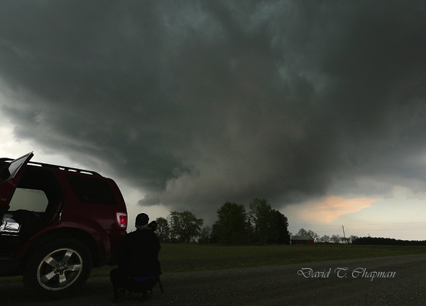
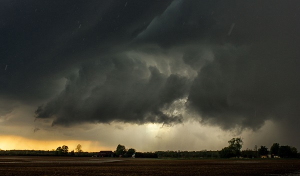
A Wall cloud in SW Ontario approaches my location as the RFD cuts around with hail starting to fall.

In 2015 I hope to achieve a few goals, one of which is to capture yet another tornado in this province, hopefully just like 2014 in an open field away from any properties. I also have set my sights on some goals with lightning and capturing it in a different perspective, I can’t go into much detail but it will be a stunning sight if I can achieve it. As far as how I believe the season will go, I do believe it will be a slow start, April and May will bring the return of storms, but I don’t expect anything too severe until June and July once the humidity and warmth really have a chance to build in. I do however once again stress to leave chasing to the pros, if you’re interested in storm spotting, please look into Canwarn, the more spotters in the province the quicker warnings can be issued thanks to verified ground reports.

Lightning by Chapman

I will be working alongside another photographer and storm spotter this year, Scott Burlovich of Restless Skies, please feel free to check out his amazing work at restless-skies.com and give him a follow on twitter @restless_skies , you can also follow my journey for the year at Lightningfastphotography.com or on twitter @spencersills. I also want to send my best wishes to David Chapman for a great 2015, and as always look forward to meeting him in the field under the Meso, stay tuned for more updates and stay sky aware this summer!

Part Two

Another winter has come and gone, although perhaps slower than a lot of us would like. At least this means that the storm season is once again upon us in Ontario. As usual, Brian Chapman and I, a father and son chase team, will be back out on the roads looking for the best images of lightning and searching for Ontario’s tornadic super cells.

We will also be in close communication with our good friends and fellow chasers, Spencer Sills and Scott Burlovich, as we tend to share a lot of information about the biggest potential storms before we go chasing. You’ll notice when you look through their photography collections that they are a couple of the best for chasing down the biggest storms in our province.

You might be curious on what we do when it comes to chasing the actual storm. Brian’s job is to be the driver. This is his first priority. Once we are parked and in a safe but photographic position for the storm, he is our main videographer. As for myself, I choose where I think the biggest storm will form from looking at weather models that meteorologists use as well as talking to fellow storm chasers in the area. I am also the main photographer. I do some video work and navigate us to the most photogenic side of the storm. This is usually right next to the most dangerous part of the storm but still in the safest position possible.

Rapidly Rotating wall-cloud photo being documented by Brian Chapman)

In the past 2 years, our team has seen and recorded a number of funnel clouds, 2 confirmed tornadoes and 4 waterspouts. One of the tornadoes was near Arthur, Ontario on August 7, 2013 and the landspout tornado was near Listowel, Ontario on May 14th 2014. The Arthur tornado was a really great one to document. It lasted for close to 15 minutes and we were able to see it from start to finish. The best part about it was the fact that  no one was injured and it caused very little damage. Those are the kinds of tornadoes we love to see because they allow you to enjoy the pure power and beauty that they possess but without injuries or major destruction.

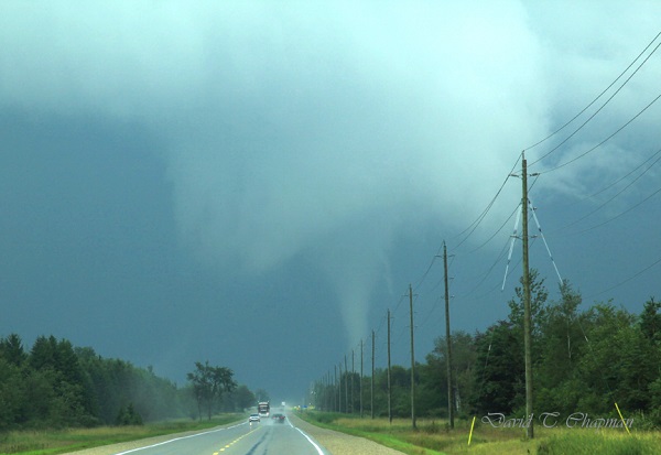
Tornado by Chapman

Another thing that was interesting with the tornado that hit near Arthur was the fact that it tried to form a second tornado at the same time the first one was on the ground. If that funnel had reached the ground, it would have been called a satellite tornado. They are typically smaller and weaker but not always. In Pilger, Nebraska in 2014, two EF-4’s were on the ground at the same time. Sadly they hit a town, killing 5 people and injuring 19. Those are the days I dread as a chaser and hope I never see first hand. As for the second funnel near Arthur, it didn’t quite have the energy to make it the rest of the way to the ground. This probably wasn’t such a bad thing with so many people focusing on the main, larger tornado just to its north.

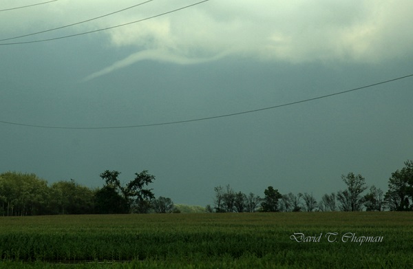
A Funnel Cloud
A Funnel Cloud

Fortunately, a lot of Ontario’s tornadoes hit open areas that cause little to no damage. There have been some exceptions, as the tornadoes that hit both Durham, Ontario on August 20, 2009 and Goderich on August 21, 2011 showed, both killing one person in each of them. That is why many storm chasers as well as dedicated weather enthusiasts in our province have a direct line to Environment Canada that allows us to contact them when we see threatening weather approaching the area we are in. It can help Environment Canada confirm what they are seeing on radar so that they can issue the proper watches and warnings accordingly. Refer to Spencer Sills’ Part One above for more details on how you can become a spotter. Lightning will also be a big focus for our team this year. We continue to work to get lightning photos as close as possible in order to capture the positive leaders that come up to meet the main negative current coming down from the cloud. The leaders can come from the ground, hydro poles, houses and even people.

Although this may be risky and dangerous, we have worked out ways to minimize the risk to us. We stay in the car when lightning is close with the windows up. We also won’t park under a tree, not so much from the fear of a direct lightning strike but in case lightning hits and splits the tree causing it to fall on the vehicle. I remember seeing one like that when I was young and it has had an everlasting impression on me. One of the first big wind storms I chased along Lake Erie on November 1, 2013 knocked down a tree onto a woman‘s car and unfortunately she was in it and was killed. So debris is always a concern and something to be very aware of when it comes to storm chasing.

You can follow our storm chasing throughout the year on our social media pages. https://twitter.com/DTChapmanPics https://www.facebook.com/pages/David-T-Chapman/173134962767601?fref=ts https://twitter.com/WeatherHunters

Toby Barrett
~CLICK ME~