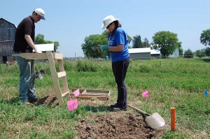
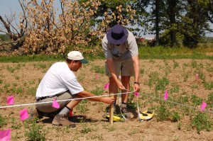
The Haldimand-Norfolk Archaeological Research Project was a regional study meant to discover new information about the past that has impacted the region such as; glaciers, climate change, prehistoric and historic settlements, wildlife, and geologic formations.
The agricultural lands of Norfolk and Haldimand County combined is approximately 2,286.49 km2 and is identified as a zone of geologic, archaeological, and historical significance, promising to reveal a great deal about past environmental events and people.
Yet, the urbanization of agricultural lands continues to alter the landscape by removing evidence of forests, tributaries, reduced land elevations, current and past ecologies, and lastly, evidence that people and their descendants once crossed the landscape of this region. For these reasons a regional study was initiated before this information is lost forever.
When you take a closer look at the landscape you can find physical evidence proving that this region is unique.
Evidence such as the scrapes and grooves on bedrock surfaces by glaciers, erratics and drumlins left behind when glaciers melted away.
Watersheds and their tributaries, originally a result of glacial melt water, continue to drain seasonal waters from the agricultural lands year round. Present day Carolinian forests represent evidence of climatic changes in the great lakes region that supported a successful transition from a tundra-like environment over 10,000 years ago.
Mega mammals such as mastodon once roamed the ecosystems of Southern Ontario only to disappear and be replaced by other mammal species.
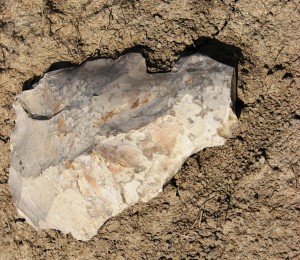
Geologic formations date back over 80 million years ago where fossils of coral reefs can be found and chert formations were formed and found across Haldimand County. People identified as Paleo-Indians used these same chert formations over 8,000 years ago to make stone tools as they crossed the landscape.
Regional studies were long-term and paid special attention to all aspects of a changing environment and landscape from one region compared to another. Typically, a regional study combines different scientific disciplines (e.g., archaeology, geology, hydrology, and paleobotany) that can bring specialists to assist with the recovery of new information. The results of a scientific study can produce new and unexpected insights into how the environment within a landscape once looked and how it was used by people.
Studies such as this create opportunities for community heritage to improve public awareness and education to understand how long term changes (e.g., climate, urbanization, and development) that can have an impact on a region.
What can a land owner expect when someone comes to their farm as part of a regional study?
Permission is always asked to begin a study of the landscape on private property. For example, I always work independently, and if help is needed, permission is asked to bring an assistant along. Once permission is given the study begins by walking over land repeatedly over a period of time and preferably free of crops.
Walking over open fields creates opportunities to examine the topography of the landscape, tributaries, plant and tree life, natural drainages, tree growth, and land elevations. Observations of prehistoric camps or historical homesteads, and their refuse pits is recorded when found.
Evidence of a camp or homesteads where people lived is called settlement patterns.
When settlement patterns are observed Geographic Positioning System coordinates are collected to record the exact location. Even though archaeological excavations are sometimes necessary, they are restricted to a small area. No excavation activity takes place unless permission is given by the landowner.
Even then, the landowner is first shown where an excavation is proposed on their property, and if crops are on the land, there is an offer of crop damage compensation based on current markets prices for wheat, soy, and corn.
A standard practice for a regional study is to recover and record the location of artifacts (e.g., prehistoric or historic) observed on the ground. These are recovered to gain new scientific insights regarding their origin, exact age, context, and association to surrounding landscapes. This includes the recovery of samples from rock formations for geologic studies.
Since regional studies are focused on private lands, all information is kept confidential and private. Information is not shared with the general public at any level, and there is absolutely no interference with farming practices whatsoever. Its business as usual! If landowners are curious to know what I am learning about the region from studying their farm land I am happy to share this information. For the Silo, Lorenz Bruechert/ Jarrod Barker.


I can show you prime farmland rotting under prarire grass, while I have to battle invasive phragmites out of my own pocket.
You can’t look after the swamps you have now, but want to make more.
This is just a plot to create more Provincially Significant Wetlands so that then municipalities can enact legislation requiring reviews in regards to building in an effort to generate more fees in order to fund it’s very existence.
ALUS program puts the farmer in the driver’s seat
The public appetite to protect and promote our natural environment continues to grow.
With the majority of southern Ontario’s land base under private ownership, it remains critical to engage those who own the land as conservation partners on the working landscape – a landscape where farmers and stakeholders can work collaboratively to conserve our soil, water, wildlife and other natural resources.
ALUS – which stands for Alternate Land Use Services – is one program that puts the farmer in the driver’s seat and promises a well-managed and protected environment at a reasonable cost.
Canada’s ALUS program recognizes that owners of agricultural land and other property owners can truly contribute to the establishment, restoration and preservation of natural ecosystems. It is a program based on setting aside marginal land recognizing owners of land. It is a voluntary, farmer-led, rancher-led, landowner-led, incentive-based program.
Projects through ALUS restore wetlands, reforest, plant windbreaks, install riparian buffer strips, build sustainable drainage systems, create wildlife habitat and establish other ecologically beneficial projects.
Secondly, participants can use their land to enhance clean air, clean water, healthy soil, flood mitigation, climate adaptation, phosphorous retention, erosion prevention, carbon dioxide sequestration and wildlife habitat.
In Europe, agricultural policies help ensure farmers are compensated for the services they provide for the whole of society in managing, conserving and enhancing the rural and natural environment.
In the United States, millions of acres of fragile farmland has been retired by paying landowners to “grass them down” through the Conservation Reserve Program.
Canada doesn’t have a federally-funded program of payments for ecological goods and services, however, we have incentives from organizations like Ducks Unlimited, Delta Waterfowl and ALUS.
All too often, bureaucrats and politicians have sought to protect the environment, by saddling farmers with restrictions and red tape that prevents them from using their land to its full potential. Through ALUS, landowners have taken leadership in an area where politicians have been slow to act. Or, when they have acted it has been to burden farmers, ranchers and property owners with rules and regulations. Hence, the importance of on-the-ground experience, evidence-based research, and he working together of all concerned to accomplish practical, common sense results. Government doesn’t have all the answers.
ALUS, developed in 2000 by Manitoba’s Keystone Agricultural Producers and Delta Waterfowl, has gained significant support from farm organizations, outdoors groups, governments and philanthropists.
The money that rolls in is significant. Principal sponsors include the W. Garfield Weston Foundation. Delta Waterfowl is a foundational partner. Other funders include David Bissett, the J. W. McConnell Family Foundation, the Alberta Real Estate Foundation, Carthy Foundation and Ontario Nature.
ALUS Canada is now a national non-profit charity. It provides per acre annual payments to farmers and ranchers, recognizing their dedication to maintaining these kinds of projects on their land. No more than 20 per cent of the farm or ranch’s workable land is enrolled although exceptions can be made.
All too often, red tape and more laws and enforcement have been the response from government, with less-than-adequate results. ALUS is a completely different approach – a refreshing approach – that is market-driven and recognizes those who own the land are key to its conservation.
Toby Barrett MPP for Haldimand and Norfolk